


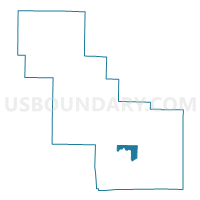
ABRAMS - T 3 Voting District, Oconto County, Wisconsin
About
Outline

Summary
| Unique Area Identifier | 695738 |
| Name | ABRAMS - T 3 Voting District |
| County | Oconto County |
| State | Wisconsin |
| Area (square miles) | 9.74 |
| Land Area (square miles) | 9.64 |
| Water Area (square miles) | 0.10 |
| % of Land Area | 98.92 |
| % of Water Area | 1.08 |
| Latitude of the Internal Point | 44.83323660 |
| Longtitude of the Internal Point | -88.04478710 |
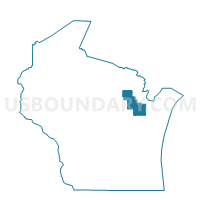
Maps

Graphs
Select a template below for downloading or customizing gragh for ABRAMS - T 3 Voting District, Oconto County, Wisconsin


Neighbors
Neighoring Voting District (by Name) Neighboring Voting District on the Map
- ABRAMS - T 1 Voting District, Oconto County, WI
- ABRAMS - T 2 Voting District, Oconto County, WI
- ABRAMS - T 4 Voting District, Oconto County, WI
- MORGAN - T 1 Voting District, Oconto County, WI
- OCONTO FALLS - T 2 Voting District, Oconto County, WI
- PENSAUKEE - T 2 Voting District, Oconto County, WI
- PENSAUKEE - T 3 Voting District, Oconto County, WI
- STILES - T 1 Voting District, Oconto County, WI
Top 10 Neighboring County Subdivision (by Population) Neighboring County Subdivision on the Map
- Abrams town, Oconto County, WI (1,856)
- Stiles town, Oconto County, WI (1,489)
- Pensaukee town, Oconto County, WI (1,381)
- Oconto Falls town, Oconto County, WI (1,265)
- Morgan town, Oconto County, WI (984)